
Reflections on Guatemala
The second country we visited on this global journey was Guatemala, and though we only stayed for about 12 days, it felt like we were there for a month because of the fullness of our experience. As such, synthesizing my thoughts has been a daunting experience in and of itself! Thankfully, Instagram and Facebook have been a great way to capture daily joys at a far more frequent and granular level (follow us by clicking on the icons on this website).
Guatemala is home to over ~16.5 million people, and has a very diverse landscape—from tall mountainous volcanoes and limestone to lush reserves and lakes. The name “Guatemala" devolved from the Mayan word, “Guatemalan,” which means “green place with lots of trees.” The concentration of people (and in many cases, problems) reside in Guatemala City—which feels like a classic non-colonial big city in Latin America, complete with smog, malls, and crime. The predominant language is Spanish (truly, as most people do not speak English), though there are over 21 recognized Mayan cultures and languages within the state. Guatemala’s recent efforts on literacy (particularly in rural areas), however, has resulted in a literacy rate that now averages more than 65%.
We visited the towns/cities of El Remate, Flores, Antigua, and Guatemala City. Throughout those very different areas, the climate remained cooler and less humid than Belize; and though it still rained daily, there were less mosquitos and “no-see-ums” than we had anticipated.
Our stay in Guatemala was marked with birds—from the chicken on the national beer can, “Gallo” (which was owned by the same owner as Las Lagunas, a very high-end hotel we splurged on for two nights so I could recover from a fatigue-induced 12-hour headache), and the thousands of birds hanging out on the telephone wires of Flores during their migration, to the humming bird paintings and home-stay pet Parrot in Antigua and the vultures of Guatemala City—but no bird captivated my heart like the Quetzal. The Quetzal is the national bird of Guatemala and were revered by the ancient Mayans, who used their tail feathers for special headdresses. The Mayans made it illegal for anyone to kill or capture the Quetzal birds because early on they knew (and it was later affirmed) that they could not live in captivity. For this reason, the Quetzal represents liberty and freedom to the Guatemalan people.

For us, Guatemala was filled with a large spectrum of experiences. We rested/recovered, laughed (see Lake House Debacle blog post), cried (as we moved beyond our comfort zones as a family and learned more about each of our inner critics), contemplated the genius of the Mayan people (Tikal), rejoiced at the splendor of nature (Volcan de Pacaya), struggled to learn and improve our command of Spanish, and bonded with new friends while volunteering on coffee farms. Below are my top three highlights (in chronological order) from Guatemala:
TIKAL
Tikal is a showpiece of the Classical period of Mayan civilization and boasts the tallest temple of all of the Mayan sites. Home of the Itza Mayans for 1600 years, it peaked as a Mayan epicenter from 700-900 AD, in which time it hosted over 250,000 inhabitants. Just as it exists today, back then the poorest people lived with the least resources on the outskirts of town, so the ruins today are really the temples and houses of the elite, who had access to the stone (and more importantly, the labor) unto build a lasting structure.
The Mayans were astronomers and had the wisdom and insight to learn from their previous trials. Their cities were perfectly planned (e.g., accessible water containers (from quarries), central cooking plazas, symmetrical spaces, etc.) and built with precision (e.g., seismic stone foundations under the temples, perfectly sized limestone bricks, etc.). For me the most impressive feature of their buildings was their exact orientation with respect to the cardinal directions; the stairs of every building pointed exactly to the N,S,E,W directions....believe me, we checked with our phones!
Because the material of the structures was natural limestone shaped by wood-burning fires and tools, it served as a natural fertilizer for regrowth and much of the Tikal was (and still is) covered by trees and because the government is trying to preserve vegetation and cover for the animals, much of it will remain covered...but that was part of the charm. It is so cool to see a mound and know that the opposite and matching pyramid (to one that is exposed) is hiding under the trees and foliage. And to top it off, the tree-top jungle view from the tops of some of these buildings was breathtaking.
Four hours flew by at Tikal, with something for everyone; Kapil reveled in the city and water/waste planning and got his workout in by going up and down literally every building; Zayan practiced some of his new-found photography skills and spotted wildlife (foxes, monkeys, spiders, and birds); Kenza interviewed our guide for a Tikal movie and got to reinforce her latest geography lesson about the cardinal directions; Kaysee got to run and climb everything and chew some natural gum (it was through sap collection from the gum tree many the Westerners learned of these ruins); and I geeked out on Mayan culture and knowledge. Our guide, Christian, and driver, Roberto, were amazing and proved to be one of our best decisions (see Lake House Debacle blog post)—and we would strongly recommend them. We had some very sore legs for the next two days, but it was so very worth it!
Amidst the awe of the Mayan genius, I was struck with how similar to our situation theirs was--specifically, at the peak of their existence and technological evolution, they exhausted their natural resources and their region could no longer support their civilization. What was their answer? To move upwards towards the Mayan Riviera and begin trading with other worlds. I can't help but wonder if this is the path of all great civilizations, or indeed humankind. When we are faced with the same learning of having exhausted every natural resource, what will be our answer? How many of us will be able to move to Mars?
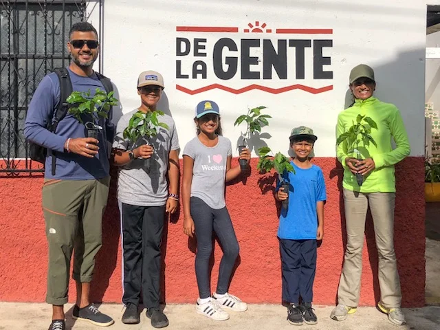
VOLUNTEERING IN GUATEMALA—DE LA GENTE
The majority of our time in Guatemala was spent volunteering at coffee plantations. In an effort to deepen our learning and connection with local people and cultures, we are volunteering throughout our journey. For Guatemala, we picked a one-week volunteer program through IVHQ, which partners with organizations in many countries to coordinate meaningful (and culturally humble) volunteerism. IVHQ’s main connection in Guatemala is with Maximo Nivel. They provided our orientation, coordinated our home stay, taught us Spanish, and served as a hub to partner with local nonprofits for various projects throughout the country. So, all that is to say, that while we received comprehensive support from Maximo Nivel (accessed through IVHQ), the nonprofit that we worked most directly with for one week, we De La Gente.
De La Gente means “of the people” in Spanish and its mission is to work with small-holder coffee farmers and cooperatives in Guatemala to create economic opportunities that improve the quality of life for their families and communities. In simple terms, they promote direct trade coffee practices, where the farmers are incentivized to produce better quality coffee and receive commensurate compensation. Because coffee takes about four years to yield income producing beans, many farmers cannot afford to go into the business (without being taken advantage of by big coffee companies). De La Gente, provides micro-lending and volunteer labor to help local farmers and then helps them to sell their coffee worldwide.
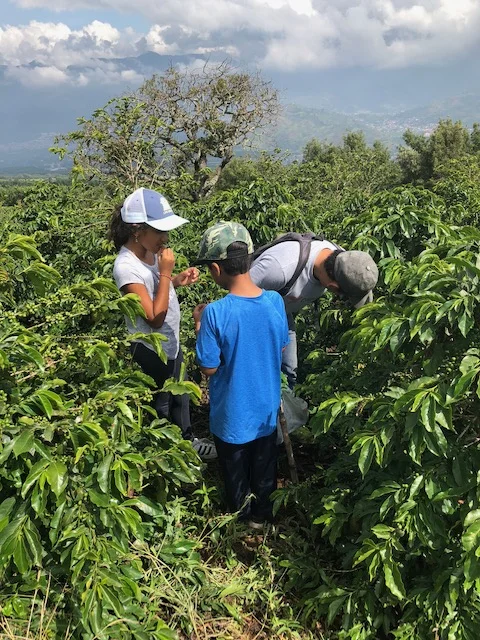
Each day, for one week, we woke up at 6am to get ready and eat breakfast, before we walked to the bus station to catch the “chicken bus” to our small town (San Miguel). We then arrived at De La Gente at 8am, where the staff greeted us with freshly French-pressed coffee while we met the farmer we would be working for and got briefed on our tasks. Most days, we would then walk/hike for about 1.5 hours up 500+m of Volcan de Agua to reach our coffee farm lot. We would then work for about 2 hours at the site on tasks like weeding, planting, digging, etc., before we hiked back down to De La Gente or the home of our farmer. We would take our bus back to Antigua for lunch and rest for an hour, before our two-hour Spanish classes! We watched the sunset daily from Antigua Brewing Company’s deck, had dinner at 7:30p with our host, and hit the sack!
We all learned so much about the coffee process, direct versus fair trade, and what it really takes to get that morning cup of coffee. We practiced our Spanish, learned about the lives of our farmers, spent time on the mountain, and contributed some hard-sweat labor! The kids tried coffee, cascara (tea made from the coffee husk), and sweet coffee cherries, and made great friends with our volunteer group, even though they were the only kids. In fact, at age 6, Kaysee currently holds the record as their youngest volunteer!
De La Gente offers subscriptions for some of the *BEST EVER* specialty coffee from Guatemala and it can be delivered right to your door! We strongly recommend that you try it out and think of us and of course, the coffee farmers, as you sip that yummy goodness! We will certainly be subscribers when we return, even at the expense of ditching Peet’s!
Kids tasting the coffee cherries!

VOLCAN DE PACAYA
Pacaya (2,552 m or 8.373 ft) is an one of the four volcanoes close to Antigua, Guatemala; and along with Volcan de Fuego, is currently active. It has “moved” over 20 times. The volcano first erupted approximately 23,000 years ago and has erupted at least 23 times since the Spanish invasion of Guatemala. Though it’s been dormant for 70 years, it has been active and frequently erupting since 1961. In fact, it was bubbling and flowing while we were there.
Getting to the top (or as high as we were allowed to go) of Pacaya was unlike any experience we’ve ever had. To get there, we hiked (kids opted for horses) for two hours through a national park, lush with jungle vegetation, huge bugs, and some fauna. As we summitted the foggy vista, I wasn’t sure that this would really be anything to write home about…but knew that at least we would have the memory of the hike. Our guide (who was amazing by the way—message us for contact info), Max, was sure that this trip wouldn’t disappoint and urged us to enter the crater to get a closer look. We walked down the crater which was like moonscape. It was filled with pointy, grey, porous rocks (petrified lava) that sounded like the Latin claves instruments one was dropped against the rest. While we stood above the clouds (or at least the majority), we got a clear vision of the active cone of the volcano with lava pouring down it’s side. All the while, we were accompanied by a cute black and white patched “chucho” which is a stray dog who joins the group to “guide” people up to Pacaya in exchange for food scraps!
Max was very comfortable with us (and we were with him) and he knew how far to push us. He maintained a tremendous respect for the volcano, but took us closer than I think he would normally take tourists. We could feel (and see) the heat from where we stood and we could hear the pops and hisses of the lava in front of us. In fact, as I was posing for a picture, I heard a pop, hiss, and the boulders break/roll behind me and I straight-up took flight (leaving our poor kids behind my view with Kapil—in fairness, they had a good view of what was going on and they were with Kapil, so I was sure the lava would just come and crush me) from the scene, so as not to be the next Pompeii statue! In doing so, I cut my ankle at several places which has yet to heal, over a week later!
We did the touristy marshmallow roasting but had to hurry as the boulders were giving way and the guides thought it was unsafe to stay longer. As we briskly, but carefully, traversed the moonscape back to the hiking trail, it began to sprinkle and we all prayed that the rain would hold out until we reached the car…especially, since now we were going to walk with our headlamps illuminating the path amidst the pitch-black darkness. Yikes—if only our parents knew what we were doing with their grandchildren—they would have had our heads!
We thankfully made it down (with the kids sharing the two horses that waited for us) with only a few rocky slips, and remained relatively dry! We fed our chucho and all failed in trying to put our magical moments to words. It was a sight and en experience for the books—and perhaps the closest we will EVER get to lava, at least if I can help it, as fate shouldn’t be tempted again and again!

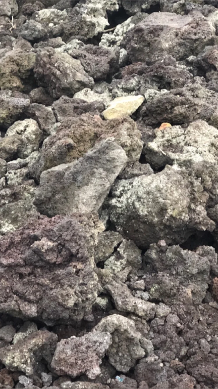
Close up picture of the moonscape :)
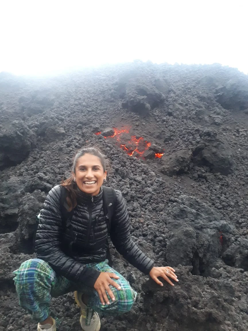
The picture right before the lava rocks behind me collapsed!
---
Guatemala will remain close to our hearts for decades to come. I can’t imagine any other 11 day experience that will show us the perilous dangers of our human behavior (see The Guajeros post) and remind us how small we really are (against the mountainous volcanoes), all at the same time. Hasta luego, Guatemala!